(UNESP - 2020 - 1 FASE)Leia o texto e analise os d
(UNESP - 2020 - 1ª FASE)
Leia o texto e analise os dois mapas para responder às questões
Cerrado

Located between the Amazon, Atlantic Forests and Pantanal, the Cerrado is the largest savanna region in South America.
The Cerrado is one of the most threatened and overexploited regions in Brazil, second only to the Atlantic Forests in vegetation loss and deforestation. Unsustainable agricultural activities, particularly soy production and cattle ranching, as well as burning of vegetation for charcoal, continue to pose a major threat to the Cerrado’s biodiversity. Despite its environmental importance, it is one of the least protected regions in Brazil.
Facts & Figures
- Covering 2 million km2, or 21% of the country’s territory, the Cerrado is the second largest vegetation type in Brazil.
- The area is equivalent to the size of England, France, Germany, Italy and Spain combined.
- More than 1,600 species of mammals, birds and reptiles have been identified in the Cerrado.
- Annual rainfall is around 800 to 1600 mm.
- The capital of Brazil, Brasilia, is located in the heart of the Cerrado.
- Only 20% of the Cerrado’s original vegetation remains intact; less than 3% of the area is currently guarded by law.
(http://wwf.panda.org. Adaptado.)
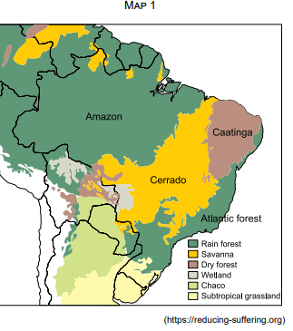
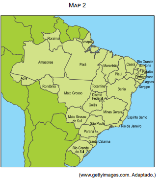
By comparing maps 1 and 2, one can say that the Brazilian administrative area totally covered by the Cerrado is
Bahia.
São Paulo
Mato Grosso.
Distrito Federal.
Paraná.


